|
|
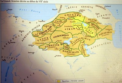
Greater
Armenia as described in the beginning of 7th century, Moutafian
& van Lauwe, Atlas historique de l'Arménie, Paris 2001, p. 13
|

|
This
is a cartographic reconstruction of a literary description made
presumably by Anania of Shirak, an Armenian scholar who lived in the
7th century.
It appears that ancient Armenia was a federation of semi-independent
principalities, each of them partially vassal to one of the
neighbouring empires. Moreover, the above description doesn't make a
clear difference between political and geographic regions.
In spite of this, the extent of the country shown here is often
presented as the "Historic Armenia". The National History Museum of
Erevan even has a fresco with a similar map in its main hall.
Although it is erroneous to deny the historical reality of a large
country called Armenia, we must recognize that its existence was
ancient and short-lived. On the other hand, the superimposition of this
map with the next one (Kurds) could be contradictory.
|
|
|
|