|
|
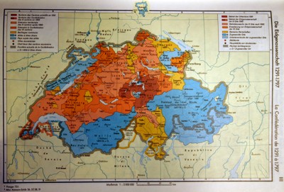
The Swiss Confederation 1291 - 1797,
Putzger Historischer Atlas zur Welt- und Schweizer Geschichte, Berlin 1981, p.III |

|
This
single map summarizes five centuries of Swiss history. The graphic
choices, colours and outlines, and the combination of 20th century
borders with ancient ones are so strange that the reader sees:
A) Switzerland like an island surrounded by a large unclear yellow zone.
B) Valtellina, Mulhouse, Rottweil and some parts of Savoy and Ossola valley as "lost territories".
In fact, during these five centuries, the Swiss Confederation was a
loose association composed of different kinds of alliances between 13
real cantons and various small states. Some cantons and statelets
were occupying, alone or jointly, vassal territories and the political
organization of the whole was particularly complex.
|
|
|
|